Lake News Alerts
We'd like to send you lake news articles, videos, and podcasts from around the web.
 We will never share your email
|
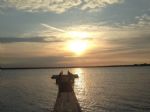
Brazos River
|
|
Length: 1280 miles (2,060 kilometers)
The Brazos River, called the Rio de los Brazos de Dios by early Spanish explorers (translated as "The River of the Arms of God") and the 11th longest river in the United States at 2,060 km from its headwater source at the head of Blackwater Draw, Curry County, New Mexico to its mouth at the Gulf of Mexico with a 45,000 square mile drainage basin.
The Brazos proper begins at the confluence of the Salt Fork and Double Mountain Fork, two tributaries of the Upper Brazos that rise on the high plains of the Llano Estacado, flowing 840 miles through the center of Texas. Another major tributary of the Upper Brazos is the Clear Fork Brazos River, which passes by Abilene and joins the main river near Graham. Important tributaries of the Lower Brazos include the Bosque River, Little River, Yegua Creek, Nolan River, and the Navasota River.
Initially running east towards Dallas-Fort Worth, the Brazos turns south, passing through Waco and the Baylor University campus, further south to near Calvert, Texas then past Bryan and College Station, then through Richmond, Texas in Fort Bend County, and into the Gulf of Mexico in the marshes just south of Freeport.
The main stem of the Brazos is dammed in three places, all north of Waco, forming Possum Kingdom Lake, Lake Granbury, and Lake Whitney. Of these three, Granbury was the last to be completed, in 1969, and its proposed construction in the mid-1950s became the impetus for John Graves' book, Goodbye to a River. There is also a small municipal dam (Lake Brazos Dam) near the downstream city limit of Waco at the end of the Baylor campus, which raises the level of the river through the city to form a town lake. This impoundment of the Brazos through Waco is locally called Lake Brazos. There are nineteen major reservoirs along the Brazos.
It is unclear when it was first named by European explorers, since it was often confused with the Colorado River not far to the south, but it was certainly seen by La Salle. Later Spanish accounts call it Los Brazos de Dios (the arms of God), for which name there were several different explanations, all involving it being the first water to be found by desperately thirsty parties.
Brazos River was the scene of a battle between the Texas Navy and Mexican Navy during the Texas Revolution. Texas Navy ship Independence was defeated by two Mexican vessels.
While the river was important for navigation before the American Civil War, it is primarily important today as a source of water for power and irrigation. The water is administered by the Brazos River Authority.
BRAZOS RIVER LAKES
|
|

|
Fort Phantom Hill Reservoir is located in Taylor County, Texas. The lake is popular destination for anglers and serves up a great variety of fish. Abilene State Park is located just 15 miles away from the lake and offers nature trails, a swimming pool and the waters of Abilene Lake, as well. Four boat ramps are located on Fort Phantom Hill Reservoi...


Full Pool: 1,635.9
Area: 4,213 Acres
|
|
|
|
|
Lake Cisco is three miles northwest of Cisco in northwestern Eastland County (at 32°26' N, 98°59' W). The lake, located on 445 acres where Sandy Creek was dammed in 1923, furnishes a water supply for Cisco. Golf and boating are also available. Lake Cisco drains an area of twenty-six square miles. It has an operating-level capacity of 8,800 acre-fee...
Full Pool: 1,520.0 MSL
Area: 1,050 Acres
|
|
|
|
|
Lake Stamford is located in Haskell County, Texas. This lake was completed in 1953 and provides water to Stamford and neighboring towns along with recreational activities. Boating, fishing, swimming, camping, and hiking are among the popular activities on the lake. The lake features it's own marina, as well....
Full Pool: 1,417.0 MSL
Area: 5,124 Acres
|
|
|
|
Hubbard Lake is located in Sandy Creek, Hubbard Creek and Brushy Creek in Stephens County, 51 miles northeast of Abilene and about five miles west of Breckenridge.
RESERVOIR CONTROLLING AUTHORITY
West Central Texas Municipal Water District
410 Hickory Street
Abilene, Texas 79601
(325) 673-8254
There are several marinas and fishing pier...
Full Pool: 1,183.0 MSL
Area: 14,922 Acres
|
|
|
|
|
*********** NOTICE *************
This area is experiencing a drought which may affect fishing and boat ramp access. Before you visit the lake for these activities, check the current lake level or contact the controlling authority for current conditions.
********************************
Lake Graham is connected ...
Full Pool: 1,075.0 MSL
Area: 1,900 Acres
|
|
|
|
|
*********** NOTICE *************
This area is experiencing a drought which may affect fishing and boat ramp access. Before you visit the lake for these activities, check the current lake level or contact the controlling authority for current conditions.
********************************
Lake Eddleman is connecte...
Full Pool: 1,075.0 MSL
Area: 650 Acres
|
|
|
|
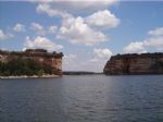
Possum Kingdom Lake, also known as P.K, is a reservoir on the Brazos River in Palo Pinto and Young counties, 75 miles west of Fort Worth off Texas Highway 16.
RESERVOIR CONTROLLING AUTHORITY
Brazos River Authority
Star Route
Graford, Texas 76025
(940) 7...
Full Pool: 1,000.0 MSL
Area: 17,700 Acres
|
|
|
|
|
***************** NOTICE *****************
Due to low water levels, all public boat ramps on this lake are closed.
**********************************
RESERVOIR CONTROLLING AUTHORITY
Palo Pinto Co Municipal Water District No. 1
PO Box 387
Mineral Wells, Texas 76067
(940) 328-7712
PUBLIC ACC...
Full Pool: 867.0 MSL
Area: 2,661 Acres
|
|
|
|
|
Lake Mineral Wells is located about four miles east of Mineral Wells in western Parker County, on Rock Creek, a tributary of the Brazos River.
This lake is located within Lake Mineral Wells State Park, which may be closed for wildlife management activities on occasion. Check the
Full Pool: 863.0 MSL
Area: 440 Acres
|
|
|
|
|
Lake Georgetown is found on the north fork of the San Gabriel River in central Texas. The lake is owned by the U.S. Army Corps of Engineers along with the dam and all adjacent properties. The dam was officially completed on October 5, 1979, and serves to provide flood control for the community of Georgetown and is also a source of drinking water.
...
Full Pool: 791.0 MSL
Area: 1,297 Acres
|
|
|
|
|
Squaw Creek is an extremely clear and deep reservoir located about four miles north of the City of Glen Rose in mid-central Texas. Public access is provided through the Squaw Creek Park. Both the reservoir and park are located at the Comanche Peak Nuclear Power Plant, with the reservoir serving as cooling water for the two nuclear power plants lo...
Full Pool: 775.0 MSL
Area: 3,275 Acres
|
|
|
|
Lake Granbury is a North Texas reservoir created in 1969 and is only one of three lakes damming the Brazos River.
The De Cordova Bend Dam contains the lake, both are controlled by the Brazos River Authority. Construction was begun on the Cordova Bend Dam on December 15, 1966; Impoundment of water began on September 15, 1969.
The lake also ser...
Full Pool: 693.0 MSL
Area: 1,350 Acres
|
|
|
|
|
Stillhouse Hollow Lake is located on the Lampasas River, southwest of Belton, Texas. The lake is also used as a recreational and wildlife area. Stillhouse Hollow Dam and the reservoir are both managed by the U.S. Army Corps of Engineers. Most of the lake is man made and was officially impounded in 1968. It provides flood control, water supply and i...
|
|
|
|
|
Aquilla Lake is located approximately seven miles southeast of Hillsboro or approximately twenty-three miles north of Waco in Hill County, on Aquilla Creek and Hackberry Creek, tributaries of the Brazos River.
The dam is part of the overall flood control project in the Brazos River basin. The lake is owned by the U.S. Government and operated ...
Full Pool: 537.5 MSL
Area: 7,000 Acres
|
|
|

|
Lake Whitney is a reservoir on the Brazos River in Texas. The lake was built for flood control and hydro-electrical power, but also serves as a great area for recreation. The lake is part of the Texas Lakes Trail Region of North Texas. The dam's construction started in 1947 and lasted four years. The lake was impounded in 1951 and the dam's power p...
|
|
|
|
|
Granger Lake is located on the San Gabriel River in central Texas. The dam, lake, and all adjacent property are managed by the U.S. Army Corps of Engineers. The reservoir was impounded in 1980 and provides flood control and recreational activities.
The reservoir is often used for fishing as well. The lake has been stocked with varying species o...
Full Pool: 504.0 MSL
Area: 4,400 Acres
|
|
|
|
|
Lake Waco is a reservoir located within the city limits of Waco, Texas. The dam is located on the Bosque River. The lake is currently run by the Army Corps of Engineers. Lake Waco was raised about 8 feet in 2005, and this has helped with fishing....
Full Pool: 462.0 MSL
Area: 7,270 Acres
|
|
|
|
|
Lake Limestone is located near Thornton, Texas. The lake's water is slightly alkaline and moderately clear, with a maximum of 42 feet deep. The Lake is controlled by the Brazos River Authority. Lake Limestone is widely used for recreational activities including fishing, motor boating, jet skiing, and swimming....
Full Pool: 363.0 MSL
Area: 13,680 Acres
|
|
|

|
Somerville Lake is owned and operated by the U.S. Army Corps of Engineers; it is located northwest of Brenham, Texas. The dam lies in Washington County, and is also managed by the U.S. Army Corps of Engineers. The reservoir was impounded in 1967; it provides flood control, water for irrigation, and a site for recreational activities.
The U.S. Ar...
Full Pool: 238.0 MSL
Area: 11,456 Acres
|
|
|
|
|
White River Reservoir is a reservoir located just 13.2 miles from Spur, in Crosby County, in the state of Texas, United States, near Kalgary, TX.
...
|
|
|
|
|
Buffalo Spring Lake is located about nine miles southeast of Lubbock in Lubbock County on the Double Mountain Fork Brazos River, a tributary of the Brazos River.
The majority of the shoreline is private property but public access is allowed for a nominal fee. A number of camping and picnic sites are available. There is one fishing house and limi...
|
|
|