Lake News Alerts
We'd like to send you lake news articles, videos, and podcasts from around the web.
 We will never share your email
|
Sabine River
|
|
Length: 575 miles (925 kilometers)
The Sabine River rises in the prairies northeast of Dallas, Texas. It flows southeast across Texas, then south to the Texas–Louisiana line. Near its mouth the river broadens to form Sabine Lake, then goes through Sabine Pass to the Gulf of Mexico. The Neches River flows into the lake. Port Arthur, Texas, is on Sabine Lake, and Orange, Texas, is on the river. The Sabine–Neches Canal divides above Port Arthur, the west branch leading up the Neches River to Beaumont and the east branch flowing to Orange. Part of the Intracoastal Waterway, it permits oceangoing vessels to reach these cities.
SABINE RIVER LAKES
|
|
|
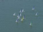
Lake Tawakoni is a reservoir located east of Dallas, Texas. It lies within three Texas counties and is used for water supply and recreation. The reservoir was constructed in 1960. It is owned by the Sabine River Authority of Texas.
...
|
|
|

|
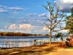
Location: Seven miles southwest of Winnsboro via SH 37; also accessible from Quitman.
Description: Recreational impoundment with lakeside parks, campsites, RV hookups, picnicking, swimming, marina, boat rentals, bait and tackle.
Facilities: Several available around lake.
Activities: Boating, boat ramps, camping, fishing, picnicking, swimm...


Full Pool: 419.0 MSL
Area: 806 Acres
|
|
|
|
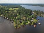
Lake Fork is located on the Sabine River in Hopkins, Rains and Wood Counties, 5 miles northwest of Quitman.
RESERVOIR CONTROLLING AUTHORITY
Sabine River Authority of Texas
Box 487
Quitman, TX 75783
(903) 878-2262
The Sabine River Authority (903) 878-2262 operates four public boat ramps and a free day use area on Lake Fork. Ther...
|
|
|
|
|
Lake Hawkins is located in Woods County, Texas. The lake offers many recreation activities including camping, boating, fishing, and swimming. The lake offer four boat access ramps and a county park with camping sites, a fishing pier, RV camping sites and picnic facilities....
Full Pool: 374.0 MSL
Area: 633 Acres
|
|
|
|
|
...
Full Pool: 363.0
Area: 653 Acres
|
|
|
|
|
RESERVOIR CONTROLLING AUTHORITY
American Electric Power
2400 FM Road 3251
Hallsville, Texas 75650
Brandy Branch Reservoir, located in Harrison County approximately seven and one-half miles southeast of Hallsville, is owned and operated by AEP-Southwestern Electric Power Company (SWEPCO) as a cooling reservoir for its Pirkey Power Plant.
...
Full Pool: 340.0 MSL
Area: 1,242 Acres
|
|
|
|
|
Martin Creek Lake is located in Rusk County, on Martin Creek 3 miles southwest of Tatum on Texas Highway 43.
RESERVOIR CONTROLLING AUTHORITY
Luminant Energy
1601 Bryan Street
Dallas, Texas 75201
(214) 875-8299
*********** NOTICE *************
To prevent the spread of zebra mussels, the law requires drainin...
Full Pool: 306.0 MSL
Area: 4,981 Acres
|
|
|
|
|
Lake Gladewater is located on Glade Creek in the City of Gladewater, 20 miles west of Longview off FM 2685 and north of US 80.
RESERVOIR CONTROLLING AUTHORITY
City of Gladewater
519 East Broadway
Gladewater, Texas 75647
(903) 845-2196
Lake Patrol (903) 845-5041
...
Full Pool: 300.0 MSL
Area: 481 Acres
|
|
|
|
An impoundment on the Cherokee Bayou, the lake is owned by the Cherokee Water Company which constructed a dam in 1948. The lake is large, spanning over 3,000 acres and surrounded by thousands more acres of community land. Home to a swelling 6,000 people, Lake Cherokee's community might as well be a town. In addition to fulltime security and lake pa...
Full Pool: 280.0 MSL
Area: 3,987 Acres
|
|
|
|
|
Lake Murvaul is located fifteen miles west of Carthage on Murvaul Bayou.
RESERVOIR CONTROLLING AUTHORITY
Panola County Fresh Water District
154 CR 1839
Carthage, TX 75633
(903) 693-6562
PUBLIC ACCESS FACILITIES
Panola County Fresh Water District maintains four improved boat ramps and one fishing pier. Camping, picnic, and restroo...
Full Pool: 265.5 MSL
Area: 3,397 Acres
|
|
|
|
|
Toledo Bend Reservoir is a reservoir on the Sabine River between Texas and Louisiana. the largest man-made body of water in Texas, the largest in the South, and the fifth largest in the United States.
The land along the Orange area often flooded from the Sabine, with destructive effects. Also, the considerations for municipal, industrial, agricu...
|
|
|
|
|
Sabine Lake is a salt water estuary on the Texas-Louisiana border. The lake is formed by the confluence of the Neches River and Sabine River. Through its tidal outlet , Sabine Pass, Sabine Lake drains some 50,000 square miles of Texas and Louisiana into the Gulf of Mexico....
|
|
|