Lake News Alerts
We'd like to send you lake news articles, videos, and podcasts from around the web.
 We will never share your email
|
Chattahoochee River
|
|
Length: 436 miles (702 kilometers)
"Chattahoochee" is an Indian word which means "river of painted rocks", possibly referring to the many colorful rock outcroppings in and along the river. The source of the Chattahoochee River is located in Jacks Gap at the southeastern foot of Jacks Knob. This is in the very southeastern corner of Union County, in the southern Blue Ridge Mountains, a sub-range of the Appalachian Mountains. The Chattahoochee River is one of the oldest and most stable river channels within the United States, since it's essentially "locked" in place, flowing along the Brevard Fault Zone, and cannot meander and change course over time like most rivers. The Chattahoochee River forms the southern half of the Alabama and Georgia border, as well as a portion of the Florida border and is about 430 miles long. The Chattahoochee, Flint, and Apalachicola rivers together make up the Apalachiacola–Chattahoochee–Flint River Basin (ACF River Basin). The Chattahoochee River makes up the largest part of the ACF's drainage basin. From its source in the Blue Ridge Mountains, the Chattahoochee River flows southwesterly to Atlanta and through its suburbs. It eventually turns due south flowing through a series of reservoirs and artificial lakes. It flows by Columbus, the second-largest city in Georgia, and the Fort Benning Army base. At Columbus, it crosses the Fall Line of the eastern United States creating a drop in elevation. This area is home to the Chattahoochee River Whitewater, the longest urban whitewater course in the world with rafting, kayaking, tubing, river surfing and more. From Lake Oliver to Fort Benning, the Chattahoochee Riverwalk provides cycling, rollerblading, running and walking along 15 miles of the river's banks. Farther south, it merges with the Flint River and other tributaries at Lake Seminole near Bainbridge, to form the Apalachicola River that flows into the Florida Panhandle.
CHATTAHOOCHEE RIVER PADDLING COURSES
|
|
|
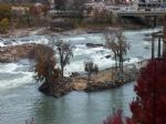
Whitewater Columbus Georgia - Phenix City Alabama Whitewater Park - The Chattahoochee River Whitewater course between Columbus, Ga. and Phenix City, Al. extends along the river from just south of the North Highlands Dam near Lake Oliver to the Dillingham Bridge in Uptown Columbus and creates the longest u...
|
CHATTAHOOCHEE RIVER LAKES
|
|
|
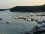
Lake Sidney Lanier, often referred to as Lake Lanier, is a reservoir in the northern portion of Georgia. Lake Lanier was created by the completion of Buford Dam on the Chattahoochee River in 1956, and is also fed by the waters of the Chestatee River. It was named for poet Sidney Lanier, and was built and is operated by the U.S. Army Corps of Engine...
|
|
|
|
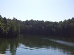
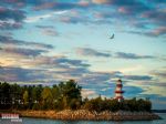
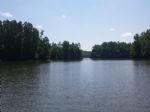
Bull Sluice Lake is a small reservoir located along the Chattahoochee River in northern Georgia, in the northern suburbs of metro Atlanta. It is 673-acres, and is impounded by the Morgan Falls Dam. Besides the hydroelectric power produced by the dam, the lake's primary use is recreation, including fishing and rowing.
Blue Sluice Lake Level Infor...


Full Pool: 797.0 MSL
Area: 674 Acres
|
|
|
|
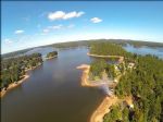
Surrounded by deep forests and rolling fields, West Point Lake extends 35 miles along the Chattahoochee River on the Alabama-Georgia state line. The lake's 500 miles of shoreline provides excellent opportunities for fishing, camping, boating and other recreational activities.
The construction of West Point Dam was authorized by the Flood Control A...
|
|
|
|
Lake Harding, Ga | Lake Harding, Al., also known as Bartlett's Ferry Lake, is a 5,850-acre reservoir on the Chattahoochee River and is formed by Bartlett's Ferry Dam. Lake Harding is just north of Columbus, Ga. and east of Auburn, Al.
Rev. Simpson Wilson Bartley operated a ferry known as Bartley's Ferry on the Chattahoochee River and in 1926, B...
Full Pool: 521.0 MSL
Area: 5,860 Acres
|
|
|
|
Goat Rock Lake is a 940-acre reservoir on the Chattahoochee River, which lies directly south of Bartlett's Ferry Dam (Lake Harding) and north of Lake Oliver. The lake is created by the Goat Rock Dam and Generating Plant. The name of the dam and lake date to the construction of the dam in 1912. Reportedly, construction workers saw goats jumping onto...
Full Pool: 404.0 MSL
Area: 940 Acres
|
|
|
|
Lake Oliver is a 2,150-acre (8.7 km2) reservoir on the Chattahoochee River, which lies south of Goat Rock Dam (Goat Rock Lake). The lake is created by the Oliver Dam and Generating Plant, which was completed in 1959 by Georgia Power.
The lake was named for James McCoy Oliver, an executive of Georgia Power at the time. Oliver Dam has four turbine...
Full Pool: 337.0 MSL
Area: 2,150 Acres
|
|
|

|
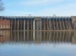
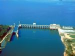
Walter F. George Lake (Lake Eufaula) is a 45,000 acre lake located on the Chattahoocee River between the states of Alabama and Georgia. This area is rich in history with many nearby historic sites and towns. The lake is nationally known for it's bass and crappie fishing. The lock, located at Ft. Gaines, Georgia, has the second highest drop east of ...
|
|
|
|
George W. Andrews Lake is an U.S. Army Corps of Engineers 29 miles south of Walter F. George Lake and north of Lake Seminole. The lake is very riverine in nature but is noted for good fishing. The purpose of the dam is for river navigation via the lock at George W. Andrews Dam. There is no hydroelectric generation at this location. The lake is name...
Full Pool: 105.0 MSL
Area: 1,540 Acres
|
|
|
|
Lake Seminole is a reservoir located in the southwest corner of Georgia along its border with Florida. The Chattahoochee and Flint rivers join in the lake, before flowing from the Jim Woodruff Lock and Dam, which impounds the lake, as the Apalachicola River. Alligators, snakes and various waterfowl are present in Lake Seminole.
The Federal Gover...
Full Pool: 77.5 MSL
Area: 37,500 Acres
|
|
|