FEATURED PADDLING COURSE
|
|
|
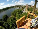
Whitewater Columbus Georgia - Phenix City Alabama Whitewater Park - The Chattahoochee River Whitewater course between Columbus, Ga. and Phenix City, Al. extends along the river from just south of the North Highlands Dam near Lake Oliver to the Dillingham Bridge in Uptown Columbus and creates the longest u...
|
RIVER CLASSIFICATIONS
Class I - Easy
Waves small, passages clear; no serious obstacles.
Class II - Medium
Rapids of moderate difficulty with passages clear.
Class III - Difficult
Waves numerous, high, irregular; rocks; eddies; rapids with passages clear
though narrow, requiring expertise in maneuvering.
Class IV - Very Difficult
Long rapids; waves powerful, irregular; dangerous rocks; boiling eddies; powerful
and precise maneuvering required.
Class V - Extremely Difficult
Exceedingly difficult, long and violent rapids, following each other almost without interruption;
riverbed extremely obstructed; big drops; violent currents; very steep gradient. Most rafting tour
operators require testing and prior Class IV or better whitewater experience.
Class VI - Unrunnable
Just like it says - Don't even think about it!
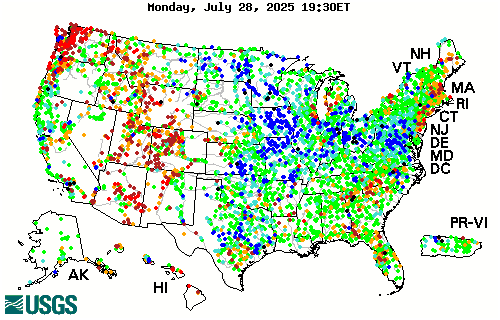
CURRENT DAILY STREAMFLOW CONDITIONS
 High  90th percentile  75th - 89th percentile  25th - 74th percentile  10th - 24th percentile  10th percentile  Low  Not ranked
The colored dots on this map depict streamflow conditions as a percentile, which is computed from the period of record for the current day of the year. Only stations with at least 30 years of record are used.
The gray circles indicate other stations that were not ranked in percentiles either because they have fewer than 30 years of record or because they report parameters other than streamflow. Some stations, for example, measure stage only.
|
|
LONGEST NORTH AMERICAN RIVERS
| Rank |
River |
Country |
Miles |
| 1 |
Mackenzie |
Canada |
2,635 |
| 2 |
Missouri-Red Rock |
US |
2,540 |
| 3 |
Mississippi |
US |
2,348 |
| 4 |
Missouri |
US |
2,315 |
| 5 |
Yukon |
US |
1,979 |
| 6 |
St. Lawerence |
Canada |
1,945 |
| 7 |
Rio Grande |
US |
1,760 |
| 8 |
Nelson |
Canada |
1,600 |
| 9 |
Arkansas |
US |
1,459 |
| 10 |
Colorado |
US |
1,450 |